
Spatial and Temporal Patterns of Sustained Heat Exposure in New Jersey Carceral Facilities
Theresa Lee
Co-Presenters: Sydnie Bogan
College: Hennings College of Science Mathematics and Technology
Major: BS.ENVIRSCI
Faculty Research Mentor: Galia Shokry
Abstract:
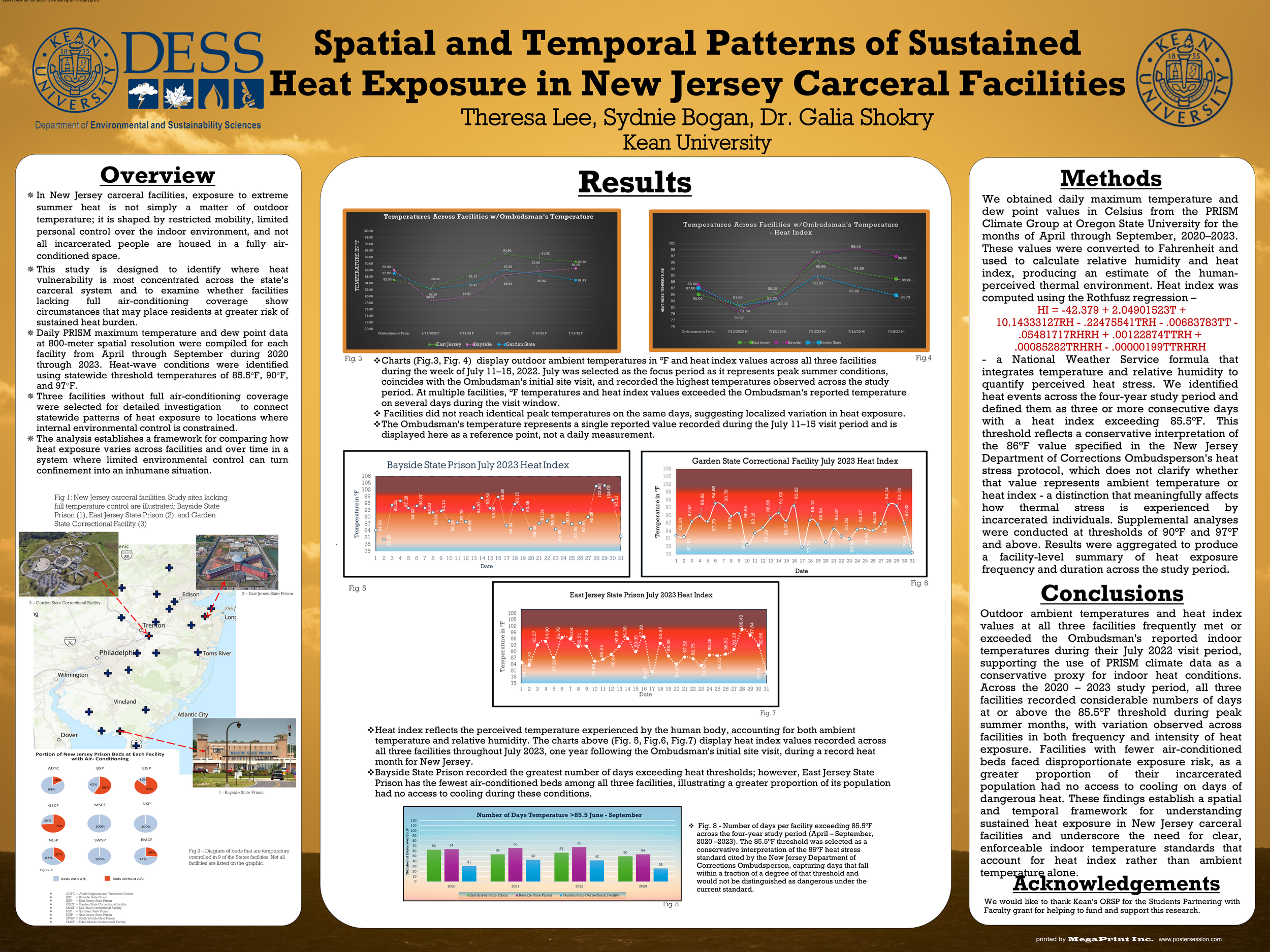
Carceral facilities are, by design, sites of constrained life and limited agency. Access to basic thermal comfort, warmth in winter and relief from extreme summer heat, is not something incarcerated individuals can control. As climate change intensifies temperature extremes, these conditions become increasingly harmful, producing sustained and cumulative bodily consequences rather than temporary discomfort. Heat in carceral spaces should therefore be understood not as an abstract climate indicator, but as an everyday, embodied pressure imposed on populations already subject to structural constraint. When rehabilitation is pursued within environments that expose individuals to preventable physical harm, the ethical boundaries of punishment and care are brought into question. Allowing incarcerated people to endure extreme heat conditions raises fundamental concerns about how societies define responsibility, dignity, and the limits of state-sanctioned suffering. This project addresses these overlooked conditions through spatial analysis that makes statewide patterns of thermal risk visible and actionable.By mapping thermal danger within these facilities, the lived experience is translated into a form that can enter the public, policy, and institutional discourse necessary for change. Visual depictions function not merely as representations, but as exercises of accountability that create possibilities for advocacy, policy pressure, and intervention. In this way, spatial data disrupts the normalization of suffering within the carceral system by challenging the assumption that extreme environmental exposure is an acceptable situation for populations already subjected to disproportionate harm. Using five years of outdoor temperature data, provided by PRISM Climate Group at Oregon State University, this project identifies and maps multi-day heat wave events, defined as periods of sustained extreme heat over three-plus consecutive days. GIS-based spatial analysis is used to map and examine the frequency and duration of these events statewide. While outdoor temperature does not fully capture how the built environment amplifies heat through concrete thermal mass, limited airflow, or population density, sustained extreme heat serves as a conservative indicator of cumulative thermal stress in settings where individuals lack control over their environment. This poster presents facility level heat exposure maps and summary indicators that translate prolonged temperature pressure and risk into a human-centered assessment of environmental danger.